
What it's really like driving through Baja California
I drove from D.C. to La Ventana: 3,400 miles and nearly 60 hours of driving

The first surprise driving through Baja was how good the highway is—at least, Rt. 5, heading directly south from Mexicali. My second surprise: Google driving times were not necessarily correct.
Last year, I skipped this trip. I flew straight to Cabo san Lucas and hired a shuttle to La Ventana, a winter kitesurfing mecca on the Sea of Cortez. It was a great trip—but mistakes were made. This year, I wanted to do everything different. Rent an apartment. Bring friends. Stay longer. Get a car.
And as for the car, ultimately, I decided to drive my intrepid Honda Fit all the way from my house outside Washington, D.C. On the map, it was approximately 3,400 miles and nearly 60 hours of driving.
Something about the trip felt appealing—the solitude, the flexibility, the chance to zone out for hours at a time, to “slow travel” across the continent. I’d also be able to pack my car with all the gear I wanted: kites, boards, and bars for kitesurfing, plus ropes, climbing shoes, and assorted gear for climbing. Finally, I wanted to stop over in New Mexico to spend Christmas and New Year with my family in Santa Fe. That would serve as a two-week layover before continuing on to Mexico.
I’d built a bed platform in the Honda that would allow me to sleep comfortably whenever I got tired—blanket, pillows, mattress pad, and all. It extended over the reclined passenger seat from glove compartment to back hatch, a total of about 80 inches. Again, the goal was flexibility. I could drive as long a day or as short of one as I wanted, and pull over to have a proper sleep whenever I felt tired.
I’d picked out a few options for sleeping near the Mexican border from iOverlander, a crowdsourced app that lists paid, free, and “wild” spots to park your van or RV overnight. The best entries have a few reviews, and often a note that someone has checked with a local authority or store manager to confirm that it’s ok to sleep there.
The plan from Santa Fe was to spend the night near the border in Yuma, Arizona. Around 10 pm, I reached my goal for the evening: a Cracker Barrel.
Most are aware that many Walmarts have a policy of letting van-lifers stay overnight in the parking lot, but it seems Cracker Barrels may actually be more reliable. Their overnight policy is company-wide (Walmart’s is store by store), and Cracker Barrels happen to be extremely ubiquitous along interstates in the south. Plus, their smaller footprint usually means it’ll be a quieter night and one less bathed in bright overhead spotlights.
When I pulled in, there were more than a dozen vans of every size and character parked. There were two trucks with teardrop trailers, and even a Prius that looked like it’d been converted into a sleeper—all the windows had reflectix insulation on them. I wasn’t the only one sleeping in a hatchback that night.
Crossing the Mexican border
I woke up at 5 am—six hours of cozy sleep. Two weeks ago in Nashville, on the way to New Mexico, it had dipped to 18 degrees and I’d struggled to keep warm; in Yuma, it had been a balmy 49 overnight. The nearest open coffee shop was a drive-through Starbucks. I picked up a laté and a chocolate croissant and headed for the border.
It was 5:40 am when I pulled up to the gate and a somewhat bemused guard asked me where I was going. A Mexico, I replied. To which he kindly replied that the border did not actually open until 6 am. I turned back, filled up on gas, and used the bathroom at a Jack in the Box attached to the station. By 6:05, I was back and crossed over without so much as a passport check.
As the sun came up and I navigated through the city, I saw going the other direction, toward the U.S. border, an unending line of cars and trucks, waiting their turn to cross. The line stretched back through city streets, block after block after block. Whoever they were, they’d clearly been queued for hours.
I wanted to cross at Mexicali because it was a big city, and also because the crossings further east involved toll roads, and I had yet to pick up any pesos. I figured the Mexicali crossing would go quickly, and perhaps I could find a bank soon thereafter to pick up some pesos for the journey.
I’d read half a dozen blog posts about driving through Baja, and they’d all advised being weary: about the lack of gas stations, the quality of gas stations (some reportedly dilute the gas with water?), the quality of the roads, the military checkpoints, and more. One post had even advised carrying extra gasoline in a jug in the car, just in case.
One is also advised not to drive at night—but not because of nefarious, nebulous bandits. It’s the cow crossings. This, at least, I could confirm. Last year in La Ventana, the main road had been crowded with cattle at all hours of day and night, and they tended to leisurely wander across when you least expected. It wasn’t a road hazard I felt like risking in the dark.
This is why I’d wanted to get an early start. The early rays of sunlight were rising in the east by about 6:15, and I wanted to get as far south as I could before the light faded in the evening, around 6, 6:30. I had a full tank of gas and suddenly no interest in finding an ATM just then, so I plowed forward toward the mountains.
South on Route 5
Route 5 runs approximately 250 miles (400 km) from Mexicali to Chapala, where it dead-ends into Rt 1, otherwise known as the Carretera Transpeninsular. As befits the name, the Transpeninsular runs more than 1,000 miles from Tijuana all the way south to Cabo San Lucas. A federal highway, Rt. 1 was completed in 1973 and has since been the standard route for West Coasters heading south.
Federal highway Rt. 5 from Mexicali, on the other hand, was just completed in 2020— and Google is still very confused.
At various times over the next few hours, Google thought I was driving directly across the open desert, with the highway hundreds of meters to my left. Perhaps this is why the time estimates were so off. The highway is no longer a windy dirt road in parts, but a long, straight, and fast freeway. As I drove south, the minutes surely and steadily ticked off my arrival time, and what google thought might take me six hours became closer to four.
To my right were the Sierra de Juárez, which rise more than 6,000 feet above sea level, and past them the Sierra de San Pedro Mártir.
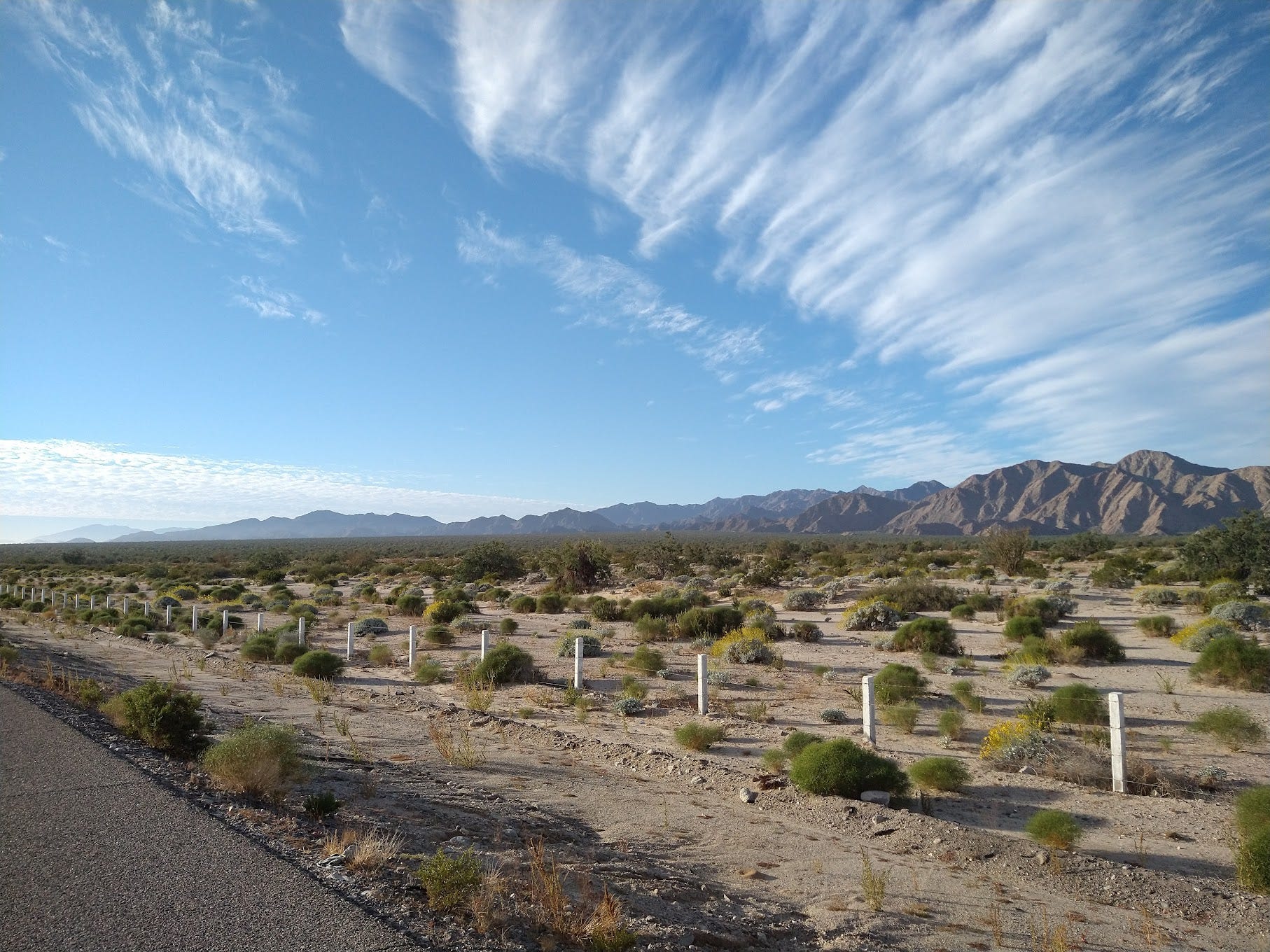
To my left, a vast flat expanse of scrub and sand. At first, I thought I was looking at the butter-flat, glasslike water you often see at dawn, and I marveled at how calm the Sea of Cortez could be at this hour. But as the sun rose a little higher I could see that no, it wasn’t water but likely the ancient sea floor where water once had been.
The first town of any size you come to is San Felipe when Rt. 5 finally hits the ocean. I had been driving for about an hour and a half not having seen any structure of any kind and only a handful of cars passing the other way. It’s true there are no gas stations for long stretches up and down the Baja peninsula, so I resolved to be conservative with my Honda’s 9-gallon tank. If it dropped below half, I would fill up at the first station I saw.
All stations in Baja are attended by workers who fill up your tank for you, a la New Jersey or Oregon, only in Mexico I was rather pleased to have someone do it for me (in New Jersey, I curse whatever unionist socialist cabal has wastefully prevented me from pumping my own gas). Next, I stopped at the Calimax, a large grocery store on the main strip in San Felipe where the gas attendant had told me I could find an ATM. There were four in the entrance: two working, and two broken.
Flush with pesos, I got back in the car and continued south. I binged the stories of risk and meaning on Climbing Gold, the podcast hosted by Alex Honold and Fitz Cahall. There was no cell reception between towns—I had only what was saved on my phone, and I congratulated myself for having downloaded the entirety of the Baja peninsula in Google Maps the night before at the Cracker Barrel (Amazingly, none of the half-dozen posts about the drive had advised this).
After San Felipe, the highway wanders along the coast. This stretch, combined with a similar stretch the next day, must surely go down as some of the most beautiful driving I’ve ever seen in my life. This, I supposed, was the idea of “slow travel,” to actually see the places I was traveling through. I was not being picked up in one airport and deposited in another thousands of miles away. I was traversing every inch of the land between. To me, it still felt as if I was moving incredibly fast, and I was. My little Honda Fit speeding 70 miles an hour through the desert would probably have appeared as God-like magic to anyone who had actually helped explore or settle this place.
On the map, Baja looks rather small, a little stick of land jutting down from California, lost amid the gigantic continent to its north and all of Mexico to the East. Driving through the large empty desert, however, you realize: it’s a bigger piece of land than you think.
The security check-points
Every so often in Baja, little speed bumps in the road give way to barriers, directing you off to the road and onto the dirt shoulder, where military police in face masks, wearing body armor, and carrying automatic assault rifles ask you a few questions about where you’ve been and where you’re going. One blog post advised me to be friendly—these men with gigantic guns are here to keep us safe, after all.
At the first two checkpoints, they waved me through. At the third, somewhere after hitting Rt. 1, a guard leaned into my car, said he smelled marijuana, and told me he would be conducting a search.
I pulled over to the side in the shade of a little shack, got out of the car, and watched as he started tossing everything: my glove compartment, where he found unused covid n95s. My cooler, with the red chile from Christmas and the sourdough starter. The grocery bag of food, my backpack. He kept muttering se huele, se huele—it smells, it smells—and the search continued.
Of course, I knew there was no marijuana, or any drugs of any kind in my car. As I told him in my basic Spanish: I had lots of clothes and things for surfing and climbing and lots of food—pero no drogas.
But I did wonder what he was smelling. The still relatively freshly cut lumber I had used to make the bed platform? The two tacos wrapped in tin foil from lunch? Did I just have body odor, or did my breath smell from two days in the car and too much bad coffee?
Of course, I began to wonder if this was one of those situations a few of the blogs warned me about, where I was supposed to offer him a low-key bribe to let me pass. In my pocket, I had plenty of pesos from the Calimax in San Felipe. But he really, truly did not appear to be trying to intimidate me. What he appeared to want very badly was to find the marijuana he was sure he’d smelled. He looked under the blankets, under the bed frame, in a kite bag, everywhere he could without actually starting to take stuff out of the car.
But after 15 minutes of searching and still no drogas, he gave up and waved me on disappointedly. Adelante.
He hadn’t even asked for my passport. No one had, even at the border.
Overnight in Mulagé
I had marked a few places from iOverlander where I could stop for the night. The first was a restaurant in Guerrero Negro, known for whale-watching tours, just over the line that separates Baja Norte from Baja Sur. But the drive was going way faster than expected, so rather than an early dinner, I sat down for a late lunch and then continued driving.
There was a roadside pull-off a ways past Guerrero Negro, where iOverlander users reported you could park behind some large dunes and spend a tranquil night, but I wanted to push on and use all the daylight I had. At this pace, I could get much closer to La Ventana and give myself an easier day tomorrow.
From Guerrero Negro, Rt. 1 traverses from West to East over the flattest part of the peninsula and through the Reserva de la Biosfera El Vizcaino. Technically, it is a large wildlife preserve, though in two hours of driving, I didn’t see much sign of wildlife (Google says the preserve protects the whales feasting off the coast). All signs of habitation disappear until you hit Santa Rosalía on the coast, and the highway again turns south along the ocean.
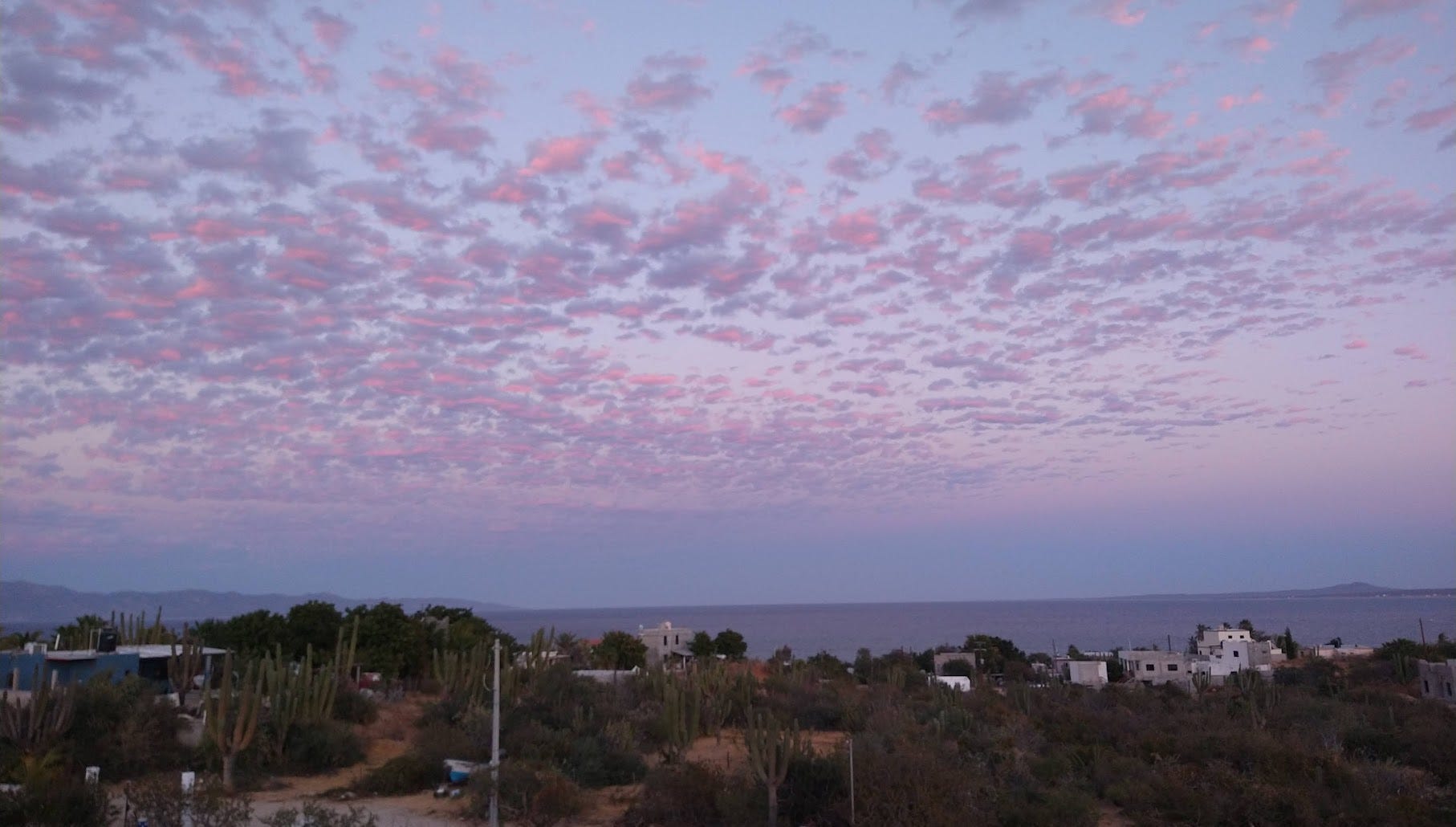
My reach goal for the day had been Mulagé, a small town that seemed to have enough restaurants along the highway that I could settle for a long dinner and a beer before overnighting. Maybe I’d even have energy to write a little. In fact, Mulagé is one of a handful of gringo hotspots, those places that, for whatever combination of natural beauty and random chance reach a tipping point of Americans and Canadians who start to colonize the place.
I could see it as soon as I drove in: little hippie coffee joints, quaint shops selling hammocks and nice clothes, every building well-painted another tone of bright orange or pink or turquoise. In contrast, Santa Rosalía, which I’d driven through half an hour earlier, appeared oblivious to the tourist economy—the streets were in typical chaos, random police trucks parked diagonal across lanes, arguing with motorists, the side of the roads littered with trash, and dogs trotting every which way. I couldn’t discern a single inviting place to stop anywhere.
But Mulagé had clearly bitten from the fruit of the tree of gringo wealth—i.e., the tourist economy. I stopped for gas once more and looked on Maps for a place to go have a beer and some dinner. A kilometer down the street was the Mulege Brewing Company. Inside, a handful of American or Canadian snowbirds in their 50s or 60s spread across two tables, chatting in English with the waitress, a flight of beer already on the table. The menu on a chalkboard on the wall listed a dozen microbrews. On the TV above the bar, a hockey game played.
Here, I knew no one would mind if I parked myself with my laptop for a few hours.
I ordered a pizza and a beer, then another. I wrote, sent some updates on my progress, and chatted with the American at the booth next to me—they were also headed to La Ventana, her husband to kitesurf. They’d been doing the annual pilgrimage south for more than a decade.
It was a typical story in Baja, similar to half a dozen conversations I’d had the year before. Part of the appeal of this peninsula is the tradition—families come and rent the same place in the same little town over and over. Or, they buy something to use each year. Or, like the old-timer at the bar I chatted with as I was paying the bill, they move here permanently, escaping a bad divorce, or a bad job, in search of a different lifestyle—the Mexican lifestyle (adapted for American tastes of course, with the IPAs on the chalkboard). Anyway, I knew the feeling. I’d already written about it the year before.
It’s truly a way of life down here.
On to La Ventana
The Americans at the brewery had recommended I sleep at Playa Santispac, where 200 pesos buys you a spot on the beach next to about a hundred other RVs and van-lifers, but I didn’t see much point. It was already well-past dark. I’d be sleeping in my car either way and would leave at first light.
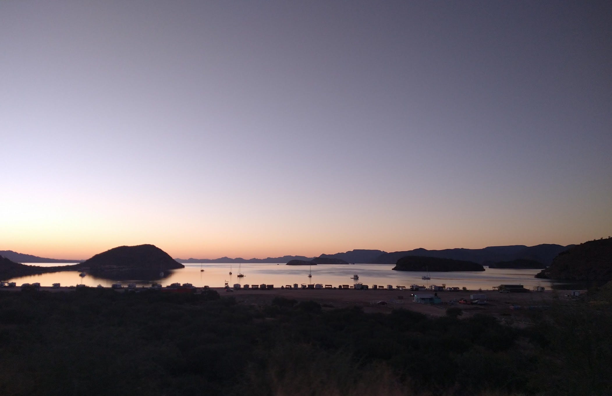
Instead, I drove back to the Pemex up the street. From iOverlander: “Popular spot for truckers to overnight park… stay along the fence kinda near the palapa (covered patio thing)." The description didn’t disappoint. There near the palapa, me and three 18-wheelers spent a quiet, restful night, and the next morning I continued on.
The road just south of Mulagé was without question the most beautiful part of the trip. I drove past Playa Santispac just before sunrise, and managed to snap a pic while descending down toward the bay:
From there, I drove steep and windy mountain roads traversing directly above the Sea of Cortez. The scenery was as gorgeous as it gets.
At this hour, I was mostly sharing the road with truckers, and I became more and more ambitious about passing them. Mexican drivers signal with their left turn light when they want you to pass. It’s a polite thing to do, and after all, they can see the road ahead much better than you can from behind. The road was narrow, but I became bold and adept at squeezing past the large trucks. Those in anything wider than my Fit would have had a much harder time—or required even more courage.
By just after noon, I’d reached La Paz, the capital of Baja California Sur, and familiar ground. The year earlier, I’d come into La Paz to wander the malecón on an off-wind day. Five years earlier, I’d been through with my son and my dad on a surfing trip. I stopped for gas, then forty minutes after La Paz, I reached La Ventana. I turned left up the familiar dirt road just past the little market, toward the apartment building with the view from the rooftop deck that I’d been looking forward to for the past ten months.
As I pulled in, I saw my friend Aymeric, the French-Canadian I’d become friends with last season, waving to me from the balcony. He came down, we shook hands, hugged, and he offered me a beer up on the rooftop. Below us, spread across the water, hundreds of kitesurfers crisscrossed the bay back and forth, back and forth.
I was back.